
Remote Sensing
Remote Sensing
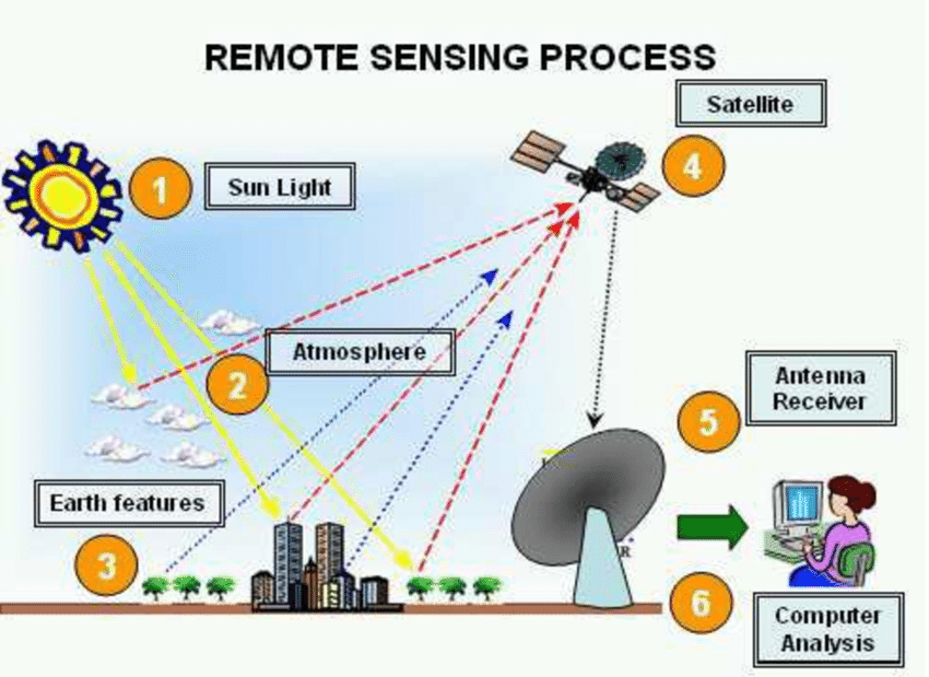
Remote sensing usually refers to the use of instruments for measuring electromagnetic radiation reflected or emitted from an object. The instruments record reflected or emitted radiation in the ultraviolet, visible, or infrared part of the spectrum. The instruments used for remote sensing may be hand-held, ground-based cameras with films and filters, digital cameras, video systems, and radiometers or they may be carried on balloons, aircraft, and satellites. The various remotesensing instruments store data obtained from field situations, and data are then printed out and are analyzed directly or by transferring them to a computer and creating visual images of data.
Image Analysis
Image analysis refers to photography and electronic image analysis, usually of large areas of fields or of mountains. The images or photographs are taken through aerial photography, ground-based sensor data, and satellite-borne and airborne sensors. Airborne mul tispectral scanning is studied and used widely for the surveillance of plant diseases, pests, and environmental stresses in agriculture. Often, infrared light or light of other wavelengths is used for the detection of the onset and progress of a plant disease among the crop plants in the field or among the fruit or forest trees in a mountain.
Plants and trees, when infected with various pathogens or subjected to other stresses, turn light green, then chlorotic (yellowish), and then brown and have different reflectances from the healthy plant. These colors or shades of colors become more distinct when photographed with the wavelengths mentioned previously than when photographed with the normal visible light spectrum. More importantly, such photographs can be examined and analyzed with specific equipment that not only better distinguishes such disease-discolored plants, but can also provide a count of the newly infected plants as well as measure the changes in intensity of the images of previously diseased plants. In that way, image analysis can provide a measure of the severity of the disease in each plant or area of infected plants and, by repetition of the photography at regular intervals, provide a measure of the rate of progress of the disease.
Information Technology
This technology involves primarily the use of computers alone or in combination with other electronic devises. They help collect data on plant diseases at various levels and various locations in a continuous manner. Data are either stored or are organized, integrated, and analyzed in tremendous quantities and at hitherto unimaginable speeds and eventually are used to
produce visual images or written reports and recommendations. Electronic information technology can, above all, describe and display spatial patterns of characteristics of different pathogens, such as their genotypes, at the scale of an agricultural region.


Download Files
- Introduction to Ecology and Epidemiology
- Elements of An Epidemic
- Host Factors that Affect Disease Epidemic
- PATHOGEN FACTORS THAT AFFECT DEVELOPMENT OF EPIDEMICS
- Environmental Factors that Affect Disease Epidemic
- Effect of Human Plant Disease Epidemic
- MEASUREMENT OF PLANT DISEASE AND OF YIELD LOSS
- PATTERNS OF EPIDEMICS
- Comparison of Epidemics
- Development of Epidemics
- Modelling of Plant Disease Epidemics
- COMPUTER SIMULATION OF EPIDEMICS
- FORECASTING PLANT DISEASE EPIDEMICS
- New Tools in Epidemiology
- New Tools in Epidemiology (GIS, GPS, Geostatistics)
- Remote Sensing
- Forecast based on initial inoculumn
- Forecast based on secondary inoculumn
- Forecast based on initial and secondary inoculum
- Risk Assessment of Plant Disease Epidemics
- Disease Warning System
- DEVELOPMENT AND USE OF EXPERT SYSTEMS IN PLANT PATHOLOGY
- DECISION SUPPORT SYSTEMS
- Exercise Assessing the Consequences of Microbial Infection in Field
- Exercise Yield Loss Implications of Different Microbial Infections
- Exercise Yield Effects of Crop Diseases
- Exercise Factors Affecting Disease Development
- Exercise Management of Greenhouse Microclimate
- Exercise Use of agri-meteorological equipment and information
- Exercise Development of Disease Predictive Model
- Exercise Use of IOT in Plant Disease Detection
- Exercise Plant Health Monitoring
- Chapters 32
- Department Plant Pathology
- Teacher
Dr. Muhammad Ahmad Zeshan
