
New Tools in Epidemiology (GIS, GPS, Geostatistics)
Geographic Information System
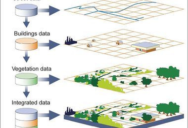
The geographic information system (GIS) is a computer system that can be installed on any recent model desktop computer and is capable of assembling, storing, manipulating, and displaying data that are referenced by geographic coordinates. GIS is adaptable to operations of any size, and data can be used at any scale from a single field to an agricultural region. It is used to better understand and manage the environment, including the understanding and management of plant disease epidemics.
GIS techniques allow one to make connections between events based on geographic proximity, connections that are essential to the understanding and management of epidemics but which often go unrecognized without GIS. GIS techniques can even incorporate disease forecasting systems, although the time and cost for it may be prohibitive. However, as high-resolution weather forecast data are often available, the development of plant disease epidemics can be predicted by knowing their dependency on some critical weather variable and from estimated geographic distribution of the pathogen inoculum within a GIS framework. GIS is often used for the spatial and temporal analysis of disease development over relatively large geographic areas and helps determine the role and relative importance of various parts of these areas in the initiation and development of the epidemic.
Global Positioning System
The global positioning system (GPS) consists of a handheld device that is coordinated with a global system of man-made satellites and, depending on the accuracy and coordination, provides quite accurate readings of the coordinates of the position of the device. GPS enables one to pinpoint an individual tree or a specific area or areas of the field that are affected by a pathogen, which then can be visited and examined again periodically for incremental advance of the symptoms. Similarly, the selected trees or areas could be treated with the appropriate pesticide or other treatment wherever the pathogen is present without the need to treat the entire field. GPS can also be used to apply pesticides, plant nutrients, and so on in only the areas of the field that are infested with the pathogen or in areas deficient in a particular micro- or macronutrient. Elimination of the pathogen from the field by early detection and treatment is often effective in not allowing the pathogen to cause an epidemic in the field and beyond.
Geostatistics
Geostatistics consist of various “geostatistical” techniques that are applied in plant disease epidemiology to characterize quantitatively spatial patterns of disease development or the development of pathogen populations in space and over time. These techniques have the capability to take into account the characteristics of spatially distributed variables whether they are random or systematic. In addition to being able to detect spatial connections, geostatistical techniques can also be used for studying continuous and discrete variables. Geostatistical techniques do not require as exacting assumptions of stationarity as do other spatial autocorrelation techniques. The spatial dependence or connection can be analyzed with semivariograms. The latter quantify spatial dependence by determining the variation between samples.


Download Files
- Introduction to Ecology and Epidemiology
- Elements of An Epidemic
- Host Factors that Affect Disease Epidemic
- PATHOGEN FACTORS THAT AFFECT DEVELOPMENT OF EPIDEMICS
- Environmental Factors that Affect Disease Epidemic
- Effect of Human Plant Disease Epidemic
- MEASUREMENT OF PLANT DISEASE AND OF YIELD LOSS
- PATTERNS OF EPIDEMICS
- Comparison of Epidemics
- Development of Epidemics
- Modelling of Plant Disease Epidemics
- COMPUTER SIMULATION OF EPIDEMICS
- FORECASTING PLANT DISEASE EPIDEMICS
- New Tools in Epidemiology
- New Tools in Epidemiology (GIS, GPS, Geostatistics)
- Remote Sensing
- Forecast based on initial inoculumn
- Forecast based on secondary inoculumn
- Forecast based on initial and secondary inoculum
- Risk Assessment of Plant Disease Epidemics
- Disease Warning System
- DEVELOPMENT AND USE OF EXPERT SYSTEMS IN PLANT PATHOLOGY
- DECISION SUPPORT SYSTEMS
- Exercise Assessing the Consequences of Microbial Infection in Field
- Exercise Yield Loss Implications of Different Microbial Infections
- Exercise Yield Effects of Crop Diseases
- Exercise Factors Affecting Disease Development
- Exercise Management of Greenhouse Microclimate
- Exercise Use of agri-meteorological equipment and information
- Exercise Development of Disease Predictive Model
- Exercise Use of IOT in Plant Disease Detection
- Exercise Plant Health Monitoring
- Chapters 32
- Department Plant Pathology
- Teacher
Dr. Muhammad Ahmad Zeshan
